Showing 2274 items matching parks victoria
-
 Greensborough Historical Society
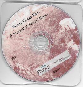
DVD, Plenty Gorge Park: a natural and social history / Parks Victoria, 2011_
... Plenty Gorge Park: a natural and social history / Parks...parks victoria...Parks Victoria... and social history / Parks Victoria. 1 DVD. This DVD gives some ...This DVD gives some detail of the Plenty Gorge Park, its natural environment and impact of man.1 DVD. plenty gorge park, parks victoria, plenty river -
 Marysville & District Historical Society
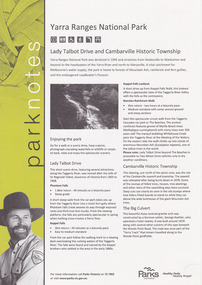
Flyer (item) - Information Flyer, Parks Victoria, park notes-Yarra Ranges National Park-Lady Talbot Drive and Cambarville Historic Township, June 2013
... parks victoria...A flyer produced by Parks Victoria of information on Lady...A flyer produced by Parks Victoria of information on Lady...Parks Victoria... and Cambarville Historic Township A flyer produced by Parks Victoria ...A flyer produced by Parks Victoria of information on Lady Talbot Drive and Cambarville Historic Township.A flyer produced by Parks Victoria of information on Lady Talbot Drive and Cambarville Historic Township. Lady Talbot Drive a 24 kilometer scenic rainforest car journey which passes a number of walks and waterfalls in the Yarra Ranges National Park. Lady Talbot Drive is named after Lady Sarah Elizabeth, the wife of Sir Reginald Talbot, who was the Governor of Victoria from 25th April, 1904 to 6th July 1908. Cambarville is notable for its giant mountain ash (Eucalyptus regnans) trees within the Cumberland Memorial Scenic Reserve, and relics from former sawmills and gold mining. The Big Culvert is located nearby on the Marysville-Woods Point Road, which was historically part of the Yarra Track. Cambarville was established as a timber mill town in the 1940s. Timber mill owners A Cameron and FJ Barton named Cambarville. They established the mill to salvage timber from trees destroyed in the 1939 bushfires. Cambarville was impacted by the 2009 Black Saturday bushfires and any remaining structures were destroyed. parks victoria, yarra ranges national park, lady talbot drive, lady talbot forest drive, cambarville, taggerty river, sir reginald talbot, lady sarah elizabeth talbot, phantom falls, keppel falls, keppel falls lookout, beeches rainforest walk, big culvert, cumberland walk, the big tree, the sitka spruce, cora lynn falls, sovereign view -
 Greensborough Historical Society
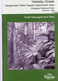
Booklet, Parks Victoria, Wallaby Creek: designated water supply catchment area. Kinglake National Park: Draft management plan 1998, 1998_02
... parks victoria...Parks Victoria.... Kingllake National Park water supply wallaby creek parks victoria ...Wallaby Creek is part of Kinglake National Park, and is a restricted access catchment area to protect quality of water supplied to Melbourne's water supply system. 26 p. black print on white paper, green cover, three folded mapskingllake national park, water supply, wallaby creek, parks victoria -
 Glenelg Shire Council Cultural Collection
Document - Portland Tourism Brochure, National Parks Victoria, n.d
... DL flyer, fold out map showing location of National Parks...National Parks Victoria... in Victoria. Full colour. National Parks Victoria ...DL flyer, fold out map showing location of National Parks in Victoria with written description of each, plus photos of various flora and fauna, prefaced by brief history of national parks in Victoria. Full colour. -
 Eltham District Historical Society Inc
Document - Book, Execon Pty Ltd, Design Proofs, Heidelberg Artists Trail, Parks Victoria
... Design Proofs, Heidelberg Artists Trail, Parks Victoria..., Parks Victoria Spiral bound A4 colour prints (42 pages ...Proof sheets for the design of signs to be placed along the Heidelberg Artists Trail for Manningham, Nillumbik, Yarra Ranges and Banyule CouncilsEach proof sheet initialled and dated by Andrew Mackenzie (24.12.1998)banyule city council, heidelberg artists' trail, manningham city council, nillumbik shire council, proof sheets, signs, yarra ranges shire council -
Marysville & District Historical Society
Flyer (item) - Information Flyer, Parks Victoria, Yarra Ranges National Park-Lady Talbot Drive, Cambarville and Lake Mountain-Visitor Guide, 01-2018
... Parks Victoria... talbot Parks Victoria ...A flyer that was produced as a guide to Lady Talbot Drive, Cambarville and Lake Mountain.A flyer that was produced as a guide to Lady Talbot Drive, Cambarville and Lake Mountain. Lady Talbot Drive a 24 kilometer scenic rainforest car journey which passes a number of walks and waterfalls in the Yarra Ranges National Park. Lady Talbot Drive is named after Lady Sarah Elizabeth, the wife of Sir Reginald Talbot, who was the Governor of Victoria from 25th April, 1904 to 6th July 1908. Cambarville is notable for its giant mountain ash (Eucalyptus regnans) trees within the Cumberland Memorial Scenic Reserve, and relics from former sawmills and gold mining. The Big Culvert is located nearby on the Marysville-Woods Point Road, which was historically part of the Yarra Track. Cambarville was established as a timber mill town in the 1940s. Timber mill owners A Cameron and FJ Barton named Cambarville. They established the mill to salvage timber from trees destroyed in the 1939 bushfires. Cambarville was impacted by the 2009 Black Saturday bushfires and any remaining structures were destroyed. Lake Mountain is the closest alpine cross-country ski resort to Melbourne.lady talbot drive, lady talbot forest drive, cambarville, lake mountain, sir reginald talbot, lady sarah elizabeth talbot -
Marysville & District Historical Society
Document (item) - Historic Site Register Sheet, Parks Victoria, Historic Site Recording System-Site Register Sheet-Chester & Locke Mine, 1989
... Parks Victoria... walker's hotel marysville victoria Parks Victoria ...A copy of a historic site register sheet for the Chester and Locke gold mine near Marysville in Victoria.A copy of a historic site register sheet for the Chester and Locke gold mine near Marysville in Victoria. The Golden Bower gold mine was a quartz reef mine. William Edward Chester discovered the Golden Secret gold vein which became part of the Golden Bower Mine at Chesterville near Donovans Creek on the Cumberland goldfield which he mined with George Locke until the late 1930s. chester and locke mine, william chester, george locke, cambarville, yarra ranges, walker's hotel, marysville, victoria -
 Greensborough Historical Society
Booklet, Parks Victoria et al, Plenty Gorge Park fire recovery, 15/04/2020
... Parks Victoria... bushfires blue lake yellow gum park plenty Parks Victoria Forest ...Community update on rehabilitation of the section of Plenty Gorge Park affected by a bushfire in December 20196 p. text and colour photographs and mapplenty gorge park, bushfires, blue lake, yellow gum park, plenty -
Glenelg Shire Council Cultural Collection
Flyer - Flyer - National Parks South West Victoria, n.d
... Flyer - National Parks South West Victoria...DL flyer, white glossy, black print. National Parks.... National Parks of South West Victoria. ...DL flyer, white glossy, black print. National Parks of South West Victoria. -
 Greensborough Historical Society
Newspaper Clipping, Parks terminate roo cull, 25/11/2015
... parks victoria...Parks Victoria decided not to cull kangaroos at Gresswell... roo cull News clipping, black text. Parks Victoria decided ...Parks Victoria decided not to cull kangaroos at Gresswell Forest Reserve.News clipping, black text.gresswell forest reserve, kangaroos, parks victoria -
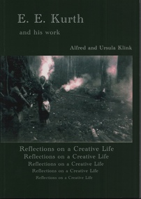 Emerald Museum & Nobelius Heritage Park
Book, Alfred and Ursula Klink, E.E. Kurth and his work, Reflections on a Creative Life by Alfred and Ursula Kling, 2014
... parks victoria... Officer of Parks Victoria). There is an Acknowledgement page...) and a Foreward by John Sullivan (Heritage Officer of Parks Victoria ...Professor Ernest Edgar Kurth of the University of Tasmania, invented a faster, simpler and cleaner way to produce charcoal on a continuous basis during the second world war. The charcoal was used to produce a combustible gas in motor cars, as a substitute for petrol, which was heavily rationed. The first batch of charcoal was produced in February 1942 and continued until the end of the war. Wood from stringybark trees was cut into lengths and fed into a kiln which converted it into charcoal. The Kiln is located on Beenak Road, 7km north of Gembrook. It has great historical significance, particularly as an alternative supplier of fuel during the second world war. It is a State Registered facility, managed by the Friends of Kirth Kiln and the park is managed by Parks Victoria Green soft covered book of 150 pages, with a photo of 2 men and a boy out in the bush with 3 fires burning.Contains a Prelude about Ernest Edgar Kurth written by Alfred Klink (2013) and a Foreward by John Sullivan (Heritage Officer of Parks Victoria). There is an Acknowledgement page, with recognition given to the grant provided by the Department of Sustainability, Environment, Water, Population and Communities. e.e. kurth, kirth kiln, charcoal kiln, parks victoria -
 Eltham District Historical Society Inc
Photograph, Peter Pidgeon, Killeavey, Laughing Waters Road, Eltham 5 Nov 2016, 5 Nov 2016
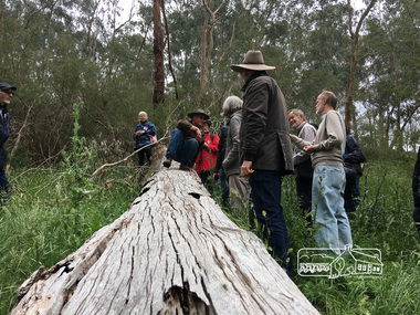
... parks victoria...Cam from Parks Victoria demonstrating how the Wurundjeri... 2016 Born Digital Cam from Parks Victoria demonstrating how ...Cam from Parks Victoria demonstrating how the Wurundjeri would have climbed the 'toe hold' tree Heriitage Excursion - Kileavey Walk and TalkBorn Digitalactivities, eltham district historical society, heritage excursion, kileavey, parks victoria, laughing waters road, eltham, wurundjeri -
 Greensborough Historical Society
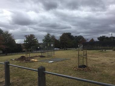
Photograph - Digital Image, Mernda historic sites 2018, 25/07/2019
... parks victoria... in the Mernda area. These photographs show remnant bush and the Parks.... These photographs show remnant bush and the Parks Victoria sign in the area ...In 2018 GHS members visited Turner's Bakery in Mernda for lunch and continued on to visit historic sites remaining in the Mernda area. These photographs show remnant bush and the Parks Victoria sign in the area.Mernda is an area of rapid modern growth with a few remaining historic buildings dating from the 19th centuryDigital copy of colour photographsmernda, parks victoria, bushland -
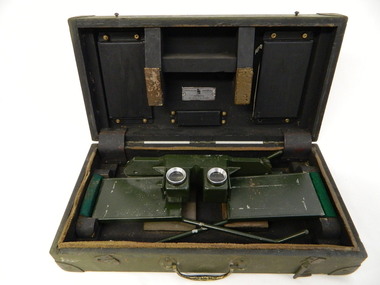 Kiewa Valley Historical Society
Stereoscope
... national parks victoria. stereoscope. aerial photographs... by National Parks Victoria located at Mt Beauty to look at aerial.... It was used by National Parks Victoria located at Mt Beauty to look ...The stereoscope was an interpretation device used to interpret aerial photography and the landscape. It was used by National Parks Victoria located at Mt Beauty to look at aerial photos so that they showed up the relief of the topography and therefore looked 3D.Used by National Parks Victoria staff located at the Mt Beauty office during the 1970's and early 1980's.Dark green wooden box with padded protection around the perimeter and on lid where 2 rectangular pieces of wood touch the stereoscope. The box is fitted with wooden dividers that fit around the stereoscope. The stereoscope is green metal with folding legs and sides attached to allow the stereoscope to sit on a surface. The instrument has 2 round glass ('mirrored viewing lens') cylinders eye distance apart, that allow light in from the side swinging doors. The amount of light is constricted by a rectangular piece of metal at the top of each leg. The box has swing clips used to close it and a metal swing handle all on the front side.The hinges are reinforced (and offer protection) by additional rubber pieces at each end. Inside the box is a brush made of bristle with a wooden handle - used for cleaning.Outside and top of box: written in black: No. 1026. On blue tape beneath: Mirror stereoscope 1026. written in black centre top of box: W10/WKA.0233. On front edge of box written in black: W10/WKA 0233. Inside box lid on silver plaque: Stereoscope Universal/ Made in / Australia / Die Casters Ltd. Victorianational parks victoria. stereoscope. aerial photographs. scientific instrument. mt beauty. 3d -
 Eltham District Historical Society Inc
Photograph, Peter Pidgeon, Killeavey, Laughing Waters Road, Eltham 5 Nov 2016, 5 Nov 2016
... parks victoria...Heriitage Excursion - Kileavey Walk and Talk Cam from Parks... Cam from Parks Victoria and Jane Woollard, author of 'Laughing ...Heriitage Excursion - Kileavey Walk and Talk Cam from Parks Victoria and Jane Woollard, author of 'Laughing Waters Road:art, landscape and memory in Eltham' were our guides today through the Morrison's property, 'Killeavey'Born Digitalactivities, eltham district historical society, heritage excursion, kileavey, parks victoria, laughing waters road, eltham, jane woollard -
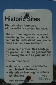
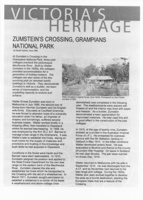 Halls Gap & Grampians Historical Society
Document - Article (magazine/newspaper)
... Article (3pages) written by David Catrice for Parks... from "Victoria's Heritage", Parks Victoria c1995..., Grampians National Park from "Victoria's Heritage", Parks Victoria ...Article (3pages) written by David Catrice for Parks Victoria. More history on Walter Zumstein and the Zumstein area can be found on p137, 153 -156, 83, 107, 136 of "Victoria's Wonderland: a Grampians History"3page Article describes Walter Zumstein and the area known as 'Zumstein's'. Entitled Zumstein's Crossing, Grampians National Park from "Victoria's Heritage", Parks Victoria c1995media, magazine articles -
 Greensborough Historical Society
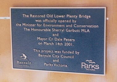
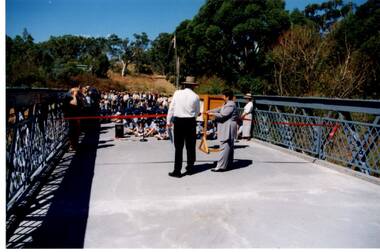
Photograph - Digital Image, Anne Paul, Plaque: Opening of restored Old Lower Plenty Bridge 2001, 14/03/2001
... parks victoria... Council and Parks Victoria.... was jointly funded by Banyule Council and Parks Victoria. lower plenty ...This plaque commemorates the opening of the restored Old Lower Plenty Bridge, opened on 14/03/2001 by the Minister for Environment and Conservation Sherryl Garbutt MLA and Mayor of Banyule Cr Dale Peters. The project was jointly funded by Banyule Council and Parks Victoria.Digital copy of colour photograph of memorial plaquelower plenty, lower plenty bridge, sherryl garbutt, dale peters, banyule council, parks victoria -
 Emerald Museum & Nobelius Heritage Park
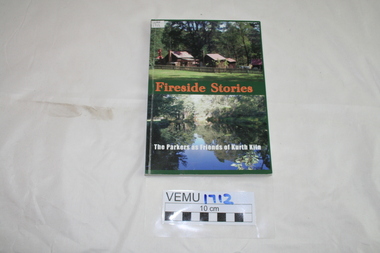
Book, Friends of Kirth Kiln, Fireside Stories, The Parkers as Friends of Kurth Kiln, February 2010
... parks victoria... of Kirth Kiln (under the auspices of Parks Victoria).... by Friends of Kirth Kiln (under the auspices of Parks Victoria ...Kith Kiln was the site of a short lived charcoal kiln designed to provide an alternative to petrol during World War 11 when there was a fuel shortage. Local history has been told by Genseric (Bill) Parker and the reflections collected by Friends of Kirth Kiln (under the auspices of Parks Victoria).The booklet is significant because it tells the story of the development of the Kirth Kiln Park in Gembrook, from the Friends perspective.The park is not only historical but is also of great environmental significance and it forms part of community life in the district. Green soft cover booklet of 128 pages. The front cover has 2 photos; the top one of the caretakers compound with Forest Commission huts and the bottom photo is of the Lake, taken from the dam on Tomahawk Creek. The back cover has a diagram of the Kiln logo.Fireside Stories with Genseric (Bill) Parker and Lorna Parker. Reflections collected by Friends of Kirth Kiln.kirth kiln, genseric parker, parks victoria, gembrook, charcoal burner -
 Greensborough Historical Society
Photograph - Digital image, Unveiling Happy Hollow plaque, 24/10/2006
... parks victoria... was later owned by Mrs Betty Bell and was purchased by Parks... by Mrs Betty Bell and was purchased by Parks Victoria in 1994 ...Photograph of descendants of past owners of Happy Hollow unveiling the commemorative plaque. Includes descendants of Charles Partington, John McLaughlin and Robert Emmett Whatmough. The land was later owned by Mrs Betty Bell and was purchased by Parks Victoria in 1994 to form part of the Plenty Gorge Parklands. This plaque was laid by Plenty Historical Society. Digital copies of 3 colour photographs.happy hollow, plenty river, john mclaughlin, charles partington, robert emmett whatmough, parks victoria -
 Greensborough Historical Society
Photograph - Digital image, Happy Hollow plaque unveiling 1 and 2, 24/10/2006
... parks victoria... by Parks Victoria in 1994 to form part of the Plenty Gorge... emmett whatmough charles partington betty bell parks victoria ...Photograph of descendants of past owners of Happy Hollow preparing to unveil the commemorative plaque. Includes descendants of Charles Partington, John McLaughlin and Robert Emmett Whatmough. The land was later owned by Mrs Betty Bell and was purchased by Parks Victoria in 1994 to form part of the Plenty Gorge Parklands. This plaque was laid by Plenty Historical Society. Digital copy of colour photograph.happy hollow, robert emmett whatmough, charles partington, betty bell, parks victoria -
 Greensborough Historical Society
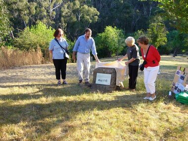
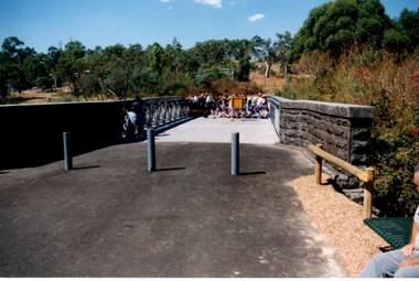
Photograph - Digital Image, Anne Paul, Opening of restored Old Lower Plenty Bridge 2001, 14/03/2001
... parks victoria.... The project was jointly funded by Banyule Council and Parks Victoria.... The project was jointly funded by Banyule Council and Parks Victoria ...The opening of the restored Old Lower Plenty Bridge, opened on 14/03/2001 by the Minister for Environment and Conservation Sherryl Garbutt MLA and Mayor of Banyule Cr Dale Peters. The project was jointly funded by Banyule Council and Parks Victoria. The restored bridge is the oldest remaining bridge in the former Shire of Eltham and forms part of the Plenty River Trail.Digital copy of colour photographlower plenty, lower plenty bridge, sherryl garbutt, dale peters, banyule council, parks victoria -
 Greensborough Historical Society
Photograph - Digital Image, Anne Paul, Opening of restored Old Lower Plenty Bridge 2001 - area adjacent, 14/03/2001
... parks victoria.... The project was jointly funded by Banyule Council and Parks Victoria.... The project was jointly funded by Banyule Council and Parks Victoria ...The opening of the restored Old Lower Plenty Bridge, opened on 14/03/2001 by the Minister for Environment and Conservation Sherryl Garbutt MLA and Mayor of Banyule Cr Dale Peters. The project was jointly funded by Banyule Council and Parks Victoria. The restored bridge is the oldest remaining bridge in Nillumbik and forms part of the Plenty River Trail. this photograph shows the area adjacent to the bridge on the day of the opening.Digital copy of colour photographlower plenty, lower plenty bridge, sherryl garbutt, dale peters, banyule council, parks victoria -
 Sunbury & District Heritage Association Inc
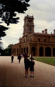
Photograph, Werribee Park Mansion, Early 1990s
... Parks Victoria... attraction in 1977 run by Parks Victoria. The photograph was taken... attraction in 1977 run by Parks Victoria. The photograph was taken ...Brothers homes and Andrew Chirnside, who emigrated from Scotland, built the Italianate -style mansion on their Werribee property between 1874 and 1877. They were pioneering pastoralists who foundered the Chirnside Pastoral Empire. The Victorian Government purchased the property in 1973 and it opened as a tourist attraction in 1977 run by Parks Victoria. The photograph was taken when the students from Bulla Primary School visited the property.The visit to Werribee Park Mansion was included in the students' history studies.A coloured non-digital photograph of a large double storey Italianite style mansion with an imposing lookout tower with flagpole over the main entrance. A large sweeping gravel driveway leads to the main entrance.school excursions, bulla primary schooil, werribee park mansion, thomas chirnside, andrew chirnside, parks victoria -
 Greensborough Historical Society
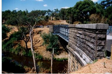
Photograph - Digital Image, Anne Paul, Opening of restored Old Lower Plenty Bridge 2001 - side view of bridge, 14/03/2001
... parks victoria.... The project was jointly funded by Banyule Council and Parks Victoria... Council and Parks Victoria. The restored bridge is the oldest ...The opening of the restored Old Lower Plenty Bridge, opened on 14/03/2001 by the Minister for Environment and Conservation Sherryl Garbutt MLA and Mayor of Banyule Cr Dale Peters. The project was jointly funded by Banyule Council and Parks Victoria. The restored bridge is the oldest remaining bridge in the former Shire of Eltham and forms part of the Plenty River Trail. This photograph shows the bridge from the side elevation, showing the bluestone and iron construction.Digital copy of colour photographlower plenty, lower plenty bridge, sherryl garbutt, dale peters, banyule council, parks victoria -
 Greensborough Historical Society
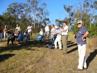
Photograph - Digital Image, Anne Paul, Opening of restored Old Lower Plenty Bridge 2001 - bridge and community, 14/03/2001
... parks victoria.... The project was jointly funded by Banyule Council and Parks Victoria... Council and Parks Victoria. The restored bridge is the oldest ...The opening of the restored Old Lower Plenty Bridge, opened on 14/03/2001 by the Minister for Environment and Conservation Sherryl Garbutt MLA and Mayor of Banyule Cr Dale Peters. The project was jointly funded by Banyule Council and Parks Victoria. The restored bridge is the oldest remaining bridge in the former Shire of Eltham and forms part of the Plenty River Trail. This photograph shows the bridge area ready for the opening ceremony and the assembled community members attending the function.Digital copy of colour photographlower plenty, lower plenty bridge, sherryl garbutt, dale peters, banyule council, parks victoria -
 Greensborough Historical Society
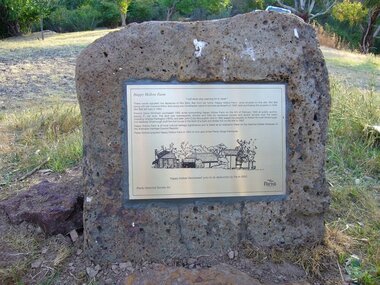
Photograph - Digital Image, Happy Hollow plaque, 05/02/1840o
... parks victoria... by Parks Victoria in 1994 to form part of the Plenty Gorge... and was purchased by Parks Victoria in 1994 to form part of the Plenty Gorge ...The land surrounding Happy Hollow farm at Plenty was purchased by Francis Wickham in 1840. The land was later subdivided and held by various owners including Charles Partington (1875) and John McLaughlin who leased the property in 1892 to Robert Emmett Whatmough who erected the first dwelling on the property. The land was later owned by Mrs Betty Bell and was purchased by Parks Victoria in 1994 to form part of the Plenty Gorge Parklands. This plaque was laid by Plenty Historical Society.Happy Hollow was an example of early settlement along the Plenty River.Digital copy of colour photograph. Plaque at Plenty Gorge Parklands.plenty river, happy hollow, happy hollow farm, robert emmett whatmough, betty bell, john mclaughlin, charles partington, parks victoria -
 Truganina Explosives Reserve Preservation Society Inc (TERPS)
Digitised Oral History – Truganina Explosives Reserve - Tape 9 Andrew Shannon and Judy Hindle, 2018
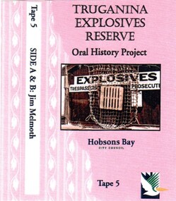
... Parks Victoria... was an environment planner, first with Parks Victoria and then the local... was an environment planner, first with Parks Victoria and then the local ...The interviews were recorded in 2000 by Bronwen Gray and Alan Young for the production of Unreserved, Stories from Truganina Explosives Reserve, animated stories from past residents, workers and interested people of the Reserve (subject to copyright 2004). Judy Hindle and Andrew Shannon worked jointly on saving the Truganina Explosives Reserve from being sold for development by the State Government. Judy was an Altona resident and Andrew was an environment planner, first with Parks Victoria and then the local council. Their motivation was to not only save the site for open space but to capture what Judy described as the only in-tact historical site in the area. A primary source of information on memories of the Truganina Explosives Reserve and Altona,VictoriaDigital copy of original cassette recorded in 2000 and digitised in 2018chirnside, explosives, tin fence, coastal vegetation, parks victoria, joan kirner, cheetham wetlands, doug grant, gahnia, salt marsh, sand ridges, rob andrew, nessie hardy, aboriginal middens, altona, truganina swamp -
Whitehorse Historical Society Inc.
Map, Proposed Mullum Mullum Park, 6/05/2008
... Map produced by Parks Victoria.... by Parks Victoria. Mullum Mullum Park maps Map produced by Parks ...Map produced by Parks Victoria.Map produced by Parks Victoria.Map produced by Parks Victoria.mullum mullum park, maps -
 Eltham District Historical Society Inc
Photograph, Fay Bridge, Toe-hold tree, Heritage Excursion, Killeavey, Laughing Waters Road, Eltham, November 2016
... Parks Victoria... replacement was demolished by Parks Victoria. Its sits high above... Heritage Excursion Kileavey Laughing Waters Road Parks Victoria ...This scar or 'toe hold' tree fell over 50 yrs ago. It had died 50yrs before it fell and is estimated to be around 400 years old. It has a diameter of 1.3 m and is the only 'toe hold' tree in Nillumbik. Heritage Excursion - Killeavey Walk and Talk - Saturday 5th November Jane Woollard’s book Laughing Waters Road Art Landscape and Memory in Eltham devotes several chapters to the property Killeavey situated on the Yarra River at the end of Reynolds Road, Eltham. Jane has written about the natural history and indigenous history of the area and stories of the family who lived at Killeavey for many years. Killeavey was the home of Sir William Irvine, Victorian and Federal Parliamentarian and Supreme Court Judge. Later it was the home of his daughter Beatrice Morrison, a significant figure in the Eltham community. The original house was destroyed by fire and its replacement was demolished by Parks Victoria. Its sits high above the Yarra River and contains significant garden remnants. The surrounding bushland is valued for its significant plant communities. In September 2011 we visited Killeavey but without the benefit of the information more recently available from Jane’s research. We are fortunate that Jane will be joining us on this walk. There will be an extended stop at the house site for a discussion on the environment and history of the area. Inside the cover panels of Jane’s book is a reproduction of the complete artwork from ‘The Symbiogenesis Project: Laughing Waters 2011 by Aviva Reed and Paul Kalemba, as displayed in the Eltham Town Centre. This walk will start at 2 pm on Saturday 5th November at the corner of Laughing Waters and Overbank Roads. - EDHS Newsletter No. 230 October 2016fay bridge collection, 2016-11-05, activities, eltham, eltham district historical society, heritage excursion, kileavey, laughing waters road, parks victoria, cameron beardsall -
Koorie Heritage Trust
Booklet, Brownlie, John et al, Wilsons Promontory National Park, 1973
... National parks and reserves -- Victoria. Parks -- Victoria... and reserves -- Victoria. Parks -- Victoria. Wilsons Promontory ...References to plants, animals, birds, sea creatures, seasons, and recommended walks to take in the park.80 p. : ill. maps ; 18 cm.References to plants, animals, birds, sea creatures, seasons, and recommended walks to take in the park.national parks and reserves -- victoria. parks -- victoria. wilsons promontory national park (vic.) -- description and travel -- guidebooks.